|
|
|
|
||||||||||||||||||||
|
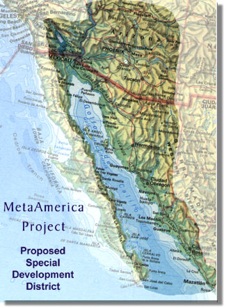
This area has abundant land and an unusually high number of cloudless days. Located between Phoenix and Tucson on the international rail line, it has an almost level path to the coast of the Gulf of California. A transportation corridor from SpaceHarbor to Puerto Penasco will need to overcome numerous legal impediments caused by right-of-way issues and the fact that it will cross an international border. The actual construction of a means for transportation is probably the easiest part of this project. Conventional rail or highway construction will be appropriate, but a more modern system can also be considered. The Azora Community Rail is a design that can serve as an interurban backbone transit system for the region with many advantages. The Puerto Penasco area has broad white sand beaches that have attracted development for many years and each development has overcome the areas limitations independently, primarily the shortage of fresh water. An economic development district to address the growth issues will be needed. The environment of the area is fragile and very related to the tides that form a complex estuarial ecosystem, which will require special consideration to preserve. The seasonal extremes of the tides are as great as anywhere in the world, annually exceeding fifty feet. The resulting expansive beaches are an entertaining stroll, so long as you stay close to higher ground. West of Puerto Penasco the shallow sea has been declared a refuge for rare aquatic mammals and other sea life. The lack of fresh water, tidal range and environmental sensitivity of the northern gulf have inhibited development for good reasons, but a macro-economic approach can solve these problems. Docking any but small craft is difficult in the northern gulf. Puerto Penasco is a rocky promontory that juts out to create a small, but usable harbor for small fishing vessels and shrimp and prawns provide a small industry for local fishermen. Their craft are small, seldom exceeding forty feet, but adequate for the purpose. Expansion of the harbor is not environmentally wise according to authorities because it would require dredging not only the harbor but a channel that would extend for over twenty kilometers (see map above) to water that is consistently deep. The solution to the harbor problem has been in operation in the English Channel for many years. Hovercraft ferries have operated between England and France for a long time, but the best model for hovercraft operation in this area is military. Shore landing strategies have for many years used shallow draft ships with flood decks to launch hovercraft landing of troops and supplies on beaches. A civilian version of this technology is the answer for the Gulf of California. The ship is conceived as a floating port, a catamaran or multi-hull design with a large flood deck aft and roll-on-roll-off doors on either side for ferrying cars, trucks and recreational vehicles. Storage for warehousing and areas for offices, medical services and luxury accommodations for passengers can be part of each vessel, each Cortez Coastal Carrier. A fleet of such carriers can circulate around the gulf so that one is passing every port once a day. Hovercraft can be based on shore or on the carrier to ferry goods and passengers to or from the shore. Each carrier and hovercraft can have a cellular communications array to maintain linkages to shore and each other while enabling passengers easy access to communications. The extent of the development proposed here will require substantial supplies of fresh water, energy and local foods. The financial viability of the area depends on having these resources at reasonable and stable prices. The source of these supplies is an anomaly in the shallow gulf, a three thousand foot deep sea canyon that can host a land-based version of the much storied Ocean Thermal Electric Conversion (OTEC) power plant. These plants usually require a substantial difference, about forty degrees, between the deep water and the warm upper water to operate the evaporation and condensation cycles, and this requirement can be met with either surface water or solar ponds adjacent to the land based facility. Additionally, it is notable that the region is prime solar energy land and can support a variety of solar energy complexes to generate power. The OTECs offer a sustainable source of fresh water, electric power and aquaculture. They are the economic foundation for a large and stable population to inhabit the shores of the Gulf of California. Attracting premium employment opportunities and the lifestyle that goes with those types of jobs are addressed by the high technology businesses needed to for the emerging space manufacturing sector and the fusion of cultures such broad-based enterprises create. The region's position on the boundary between English-speaking North America and the Latin cultures of South America is further complemented by its exposure to Pacific Rim trade contacts. A macro economic plan for the region that includes all of these elements will be successful. Strategic issues associated with implementing any or all of this project will require the efforts of nations and global entities such as the World Bank and United Nations, but it is the type of project that should interest all of these. World events will determine when they can turn their attention to projects of this scope. The Sea of Cortez will be waiting. |
| [MetaAmerica] [Space Harbor] [Azora] [Penasco] [Carriers] [OTECortez] [Strategy] |
|
Copyright © Dane M Arr 2001 All rights reserved. ABOUT THIS WEB SITE: The MetaAmerica Project web site is an ongoing effort to facilitate discussion about the long term potential of the US/Mexico and Arizona/Sonora economic development relationship. Planned additions to this site include discussion groups and consortia pages. The idea of consortia is rooted in the economic opportunity inherent in the investment required to develop the region, and the many significant technologies needed to do it.
|
 |
|||||||
|
|||||||
 |
|||||||
|
This area for links to related information... |
|||||||